Among the 59 new names recently announced by the International Astronomical Union (IAU) are two Babylonian (Udkadua, Uridim), one ancient Egyptian (Apdu), four ancient Greek (Deltoton, Phyllon-Kissinou, Hydor, Kamelos), ten Latin, six Arabic and two Sanskrit (Shatabhisha, Apamvatsa). All names can be found in the IAU Catalog of Star Names (CSN) and are explained in the IAU All Skies Encyclopaedia (ASE): https://ase.exopla.net/
The IAU has been the arbiter of star names and planetary nomenclature since its inception in 1919, later recognised by the United Nations. This naming process is carried out by its working groups. The current Chair of the Working Group on Star Names resides at Institut für Wissensgeschichte.
Research Group Leader Anuj Misra interviewed by Berliner Antike Blog on astral knowledge in transregional Asia, his roles at the Freie Universität Berlin and MPIWG, and the driving motivations behind his scholarly work.
After the end of World War II and the defeat of the German Nazi regime, Berlin was divided into four Allied occupation zones in July 1945. These zones were managed by the respective occupying forces: the United States controlled the southwestern part of Berlin, Great Britain managed the western area, France oversaw the northwestern section, and the Soviet Union governed the northeastern, eastern, and southeastern parts of the city. Together, these powers ruled Berlin.
Soon after these events, tensions, and ideological differences between the capitalist democracies of the USA, Western Europe, and Canada, on one side, and the communist regime originating from the Soviet Union, on the other, increased.
In 1948, the Soviet Union imposed an economic and territorial blockade on West Berlin, which was controlled by the Western Allies: the USA, Great Britain, and France. This event marked the beginning of the Cold War’s impact on Germany and Berlin. The establishment of the Bundesrepublik Deutschland (BRD) and the Deutsche Demokratische Republik (DDR) in 1949 further solidified this division.
The construction of the Berlin Wall in August 1961 represented the climax of confrontation during the Cold War from a German perspective.
The Cold War significantly influenced the city of Berlin and its residents, impacting the city’s development since the 1960s. Even over 30 years after the Cold War ended – marked by the fall of the Berlin Wall in 1989, the dissolution of the DDR in 1990, and the collapse of the Soviet Union in 1991 – traces of this ideological, military, and political confrontation remain evident in Berlin’s cityscape.
Some of the architectural remnants from the Cold War are presented in the following lines of this blog post. The selection of these traces is subjective and not exhaustive, and it was influenced by their relative accessibility. This post aims to encourage readers to explore the traces of the Cold War in Berlin on their own.
The Teufelsberg
The Teufelsberg is a large mound located in the Grunewald, which is part of the Charlottenburg-Wilmersdorf district in the former British occupation zone. This mound was constructed using the rubble from the ruins of World War II, specifically the remnants of the Wehrtechnische Fakultät der Technischen Hochschule, a project planned by Albert Speer in the 1930s but never completed. The site was ultimately destroyed during Allied bombings in 1945.
By 1960, the mound reached a height of approximately 120 meters. In the 1960s, the Western Allies, specifically Great Britain and the USA, established a signals intelligence interception station at the top of the mound.
In 1961, the first devices used at the listening station were mobile trucks and trailers. This setup was used by the British and American military to intercept radio signals from the DDR and other Warsaw Pact countries. By 1964, most of these mobile units were replaced with the first permanent buildings.
The Field Station Berlin underwent a comprehensive redevelopment starting in the late 1960s as part of Project Filman. This redevelopment included the completion of two significant buildings: a two-story operations building for the British and a larger three-story main operations building for the Americans, both of which were finished in 1972.
Between 1978 and 1982, further less important new devices were installed. During the 1980s most parts of the Field Station Berlin were remodeled and upgraded.
The listening station, located in a unique area of West Berlin and surrounded by the DDR, was ideally positioned to intercept military and political radio signals from the east. Its proximity to other Warsaw Pact states made it an excellent location for this purpose.
The Berlin Wall opened on November 9, 1989, and the reunification of Germany took place the following year, marking the end of the Cold War. As a result, Field Station Berlin became obsolete. In the early 1990s, the entire facility was dismantled.
The former listening station site is now accessible for a fee. The remaining structures, which have been partially demolished, are now adorned with street art paintings and installations that have emerged over the past 20 years. The site is mainly frequented by tourists seeking what they believe are spectacular photo opportunities to share on their social media accounts. However, today’s visitors only receive a superficial understanding of the site’s historical significance in Berlin due to its current presentation.
The Gare Française Berlin-Tegel
The French occupational zone was in the northwestern part of West Berlin, specifically in the districts of Reinickendorf and Wedding. In Tegel, a borough of Reinickendorf, the French occupational forces constructed a railway station known as Gare Française. This station was built in 1947 and has been in use since December 6 of that same year.
The station building is a single-story structure with main entrances on its longer sides.
After the Gare Française Berlin-Tegel began operating, France became the only Western Allied occupation power with a direct train connection to West Berlin. Trains ran three times a week between Strasbourg and West Berlin. This service was used for transporting military personnel and equipment, as well as for the families of French soldiers stationed in West Berlin. Even French exchange students came to West Berlin via this station.
The Gare Française Berlin-Tegel was in use until September 1994.
The Berlin Wall is probably the most famous symbol and material trace of the Cold War. It impressively manifests the division of Berlin, Germany, Europe and even the world.
From an archaeological perspective, the Berlin Wall served primarily as part of the DDR’s border security along the border between East and West Germany.
The regime referred to it as the “Antifaschistischer Schutzwall“. However, the wall was less about protecting against an invasion by Western forces and more about containing its own citizens from emigrating.
Around 140 persons were killed or died while attempting to cross the Berlin Wall from east to west. In total, more than 1000 lost their lives along the German-German border while trying to overcome it.
The Berlin Wall encircled West Berlin over a length of approximately 160 km.
The construction of the Berlin Wall began on August 13, 1961, following the orders from the political leadership of the DDR regime, with the oversight and protection of the East German Volkspolizei and the East German Nationale Volksarmee.
The border security facilities around West Berlin were extended and expanded in several phases and underwent significant changes between 1961 and 1989. This included the demolition of houses directly adjacent to the Wall to create a clear line of sight and shooting range along the eastern side of the border. Further fortifications along the 30 to 500-meter-wide border strip included various features such as trenches designed to stop vehicles from crashing into the wall, patrol zones protected by armed guards and dogs, watchtowers, and searchlights. The “Hinterlandmauer” was a second wall line at the eastern end of the border strip and the first obstacle that stood in the way of the escapees. It was erected in 1962.
After the fall of the Berlin Wall and the end of the Cold War, as well as the “Wiedervereinigung”, the wall was largely demolished and dismantled during the 1990s. In that decade, various sections of the wall that were removed were sold to interested parties in Berlin. Many areas of the border and remnants of the wall have since been rebuilt or have become overgrown with vegetation. Today, only a few remnants of the Berlin Wall can still be seen within the cityscape of Berlin.
Bibliography
R. Bernbeck, Rezension zu: Wayne D. Cocroft / John Schofield, Archaeology of the Teufelsberg. Exploring Western Electronic Intelligence Gathering in Cold War Berlin. Routledge Archaeologies of the Contemporary World. Routledge, London 2019, Germania 99, 2021, 329–334
W. D. Cocroft, The Archaeology of Military Communications, Industrial Archaeology Re-view 35, 2013, 65–79
W. D. Cocroft – J. Schofield, Archaeology of the Teufelsberg. Exploring Western Electronic Intelligence Gathering in Cold War Berlin (Abingdon – New York 2019)
H. M. Harrison, Die Berliner Mauer. Ein Symbol des Kalten Krieges?, in: L. Schmidt – H. von Preuschen (Hrsg.), On both Sides of the Wall. Preserving Monuments and Sites of the Cold War Era. Auf beiden Seiten der Mauer. Denkmalpflege an Objekten aus Zeiten des Kalten Krieges (Bad Münstereifel 2005), 18–27
L. Schmidt – H. von Preuschen (Hrsg.), On both Sides of the Wall. Preserving Monuments and Sites of the Cold War Era. Auf beiden Seiten der Mauer. Denkmalpflege an Objekten aus Zeiten des Kalten Krieges (Bad Münstereifel 2005)
L. Schmidt – H. von Preuschen, Einführung, in: L. Schmidt – H. von Preuschen (Hrsg.), On both Sides of the Wall. Preserving Monuments and Sites of the Cold War Era. Auf beiden Seiten der Mauer. Denkmalpflege an Objekten aus Zeiten des Kalten Krieges (Bad Mün-stereifel 2005), 8–10
L. Schmidt, Die Berliner Mauer. Eine Erinnerungslandschaft, in: L. Schmidt – H. von Preuschen (Hrsg.), On both Sides of the Wall. Preserving Monuments and Sites of the Cold War Era. Auf beiden Seiten der Mauer. Denkmalpflege an Objekten aus Zeiten des Kalten Krieges (Bad Münstereifel 2005), 11–17
J. Schofield – W. Cocroft (Hrsg.), A Fearsome Heritage. Diverse Legacies of The Cold War (Walnut Creek 2007)
J. Schofield – W. Cocroft – M. Dobronovskaya, Cold War. A Transnational Approach to a Global Heritage, Post-Medieval Archaeology 55, 2021, 39–58
J. Schofield – A. Schofield, Ansichten der Mauer. Alliierte Perspektiven, in: L. Schmidt – H. von Preuschen (Hrsg.), On both Sides of the Wall. Preserving Monuments and Sites of the Cold War Era. Auf beiden Seiten der Mauer. Denkmalpflege an Objekten aus Zeiten des Kalten Krieges (Bad Münstereifel 2005), 36–43
C. Theune, Archäologie an Tatorten des 20. Jahrhunderts2 (Darmstadt 2016)
The Institute for the History of Knowledge in the Ancient World warmly congratulates Sona C. Eypper who successfully defended her doctorate on September 18, 2024 and graduated with “magna cum laude”.
Sona C. Eypper studied Ancient History with a concentration on Ancient Mesopotamia under William A. Ward (1928-1996) at the American University of Beirut. Her MA thesis dealt with the chronology of Babylon during the early second millennium B.C. She came to Germany with a German Exchange Scholarship (DAAD) to study Assyriology at the Freie Universität Berlin under Franz Köcher, an Assyriologist and medical historian at the Institute for the History of Medicine.
Franz Köcher (1916-2002) started his research at the Freie Universität Berlin in 1963. His magnum opus, “Die Babylonisch-Assyrische Medizin in Texten und Untersuchungen” (BAM) is until today among the most important publications for the study of ancient Near Eastern medicine. Between 1963 and 1980, Köcher published six volumes in the BAM series and retired in 1983.
Having returned to the field after several years, Sona Eypper researched Mesopotamian medical texts dealing with conditions and diseases of the feet, under Prof. Markham J. Geller, her PhD supervisor, who has been investigating the practice of medicine and healing in Mesopotamia for decades and was at Freie Universität Berlin from 2010 until 2018. Markham J. Geller was on secondment from the University College London (UCL) to work in Berlin as a Professor for the History of Knowledge at the Topoi Cluster of Excellence. Prof. Geller also led an ERC advanced grant for “Babmed – Babylonian Medicine” (2012-2018), where Sona C. Eypper worked as a guest researcher and project advisor.
Sona Eypper with the members of the doctoral committee: Mathieu Ossendrijver (left side), J. Cale Johnson and Maria Teresa Renzi-Sepe
In her doctoral thesis, Sona Eypper investigates a particular group of Babylonian-Assyrian medical texts that deal with conditions which affect the lower extremities of the human anatomy. These conditions include not only locomotor syndromes, but also skin conditions (lesions) that appear on the legs and feet. The first two chapters of this study present fifty-two texts, mostly fragmentary, in transliteration and translation. In the lengthy third chapter, each condition is discussed and the recommended treatment procedures are analyzed. The underlying principle in Mesopotamian medicine can be best understood as a visually oriented medicine. The realization of this fact helps us to understand the various treatments.
Dr. des. Eypper is currently preparing her doctoral work for publication.
“Tell me your zodiac sign (and your ascendant) and I tell you what kind of person you are.” Casting horoscopes is very popular nowadays. People of all ages and cultural backgrounds ask the stars about their character traits, about their compatibility with other people, or about how successful their career will be.
It is well established that the practice of casting horoscopes had its roots in Mesopotamia, and to be more precise – in Babylonia, at the end of 5th BC. At present, about thirty Babylonian horoscopes (Rochberg 1998) are known to us, and they were found in the cities of Babylon and Uruk, except for an unusual example found in Nippur. Babylonian astrology is a sophisticated science. It is the result of centuries of celestial divination and complex mathematical calculations that made it possible to predict the movements of celestial bodies. Horoscopes are not the only type of astrological text that the Babylonians produced, but they are the closest link to modern astrology. Were horoscopes made in the same way back then as they are made today? What has changed?
The Babylonian horoscopes are short cuneiform texts which all begin with an indication of a child’s birth date. Some of the tablets found in Uruk even record the child’s name. Next, they report the position of the planets: the Moon (sîn), the Sun (šámaš), Jupiter (MÚL.BABBAR), Venus (dil-bat), Mercury (GU4.UD), Saturn (GENNA) and Mars (AN). Their positions were calculated with sophisticated algorithms – and not observed. Astronomically calculated positions of planets at the time of birth are what in modern astrology is known as the “natal chart”. Although the Copernican Revolution taught us that the earth is not at the center of the solar system (a thousand years after Aristarchus of Samos‘ first attempt), modern astrology still does it the Babylonian way —the place of birth on earth is the point of reference, and the Sun, Moon and the other planets are located somewhere along an imaginary band, called the zodiac, which is divided into twelve equal parts, the zodiac signs. In modern popular astrology, great emphasis is given to the “personal zodiac sign,” which is the part of the zodiac where the sun was at the time of birth. For the Babylonians, the solar zodiac sign – as far as we know – did not play an important role in horoscopy. They would not, for instance, have formed a view such as “I am a Scorpio, and thus stubborn by nature.”
The rest of the information contained in the Babylonian horoscopes varies widely. Some texts from Babylon also record the moon’s passage near certain reference stars (called “normal stars” in the literature), the date of certain lunar events that occur at the beginning, middle and end of the month (“Lunar Three”), and the dates of eclipses, solstices, and equinoxes that fall closest to the date on which the child came into the world. On the other hand, some texts from Uruk indicate whether the moon was moving up or down with respect to the zodiac at the time of birth. These elements, however, are foreign to modern astrology.
So what do all these astronomical elements tell us? What is their astrological significance? The texts themselves do not give us many clues as to how these astronomical data should be interpreted. Yet there are two “astrological” terms that may point us toward a partial understanding of Babylonian horoscopy. These, always followed by the name of a planet, are:
bīt niṣirtu, literally “house of secrecy/protection” (found in texts from Babylon);
KI “place, location” (found in texts from Uruk).
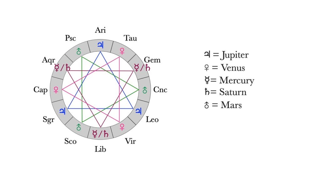
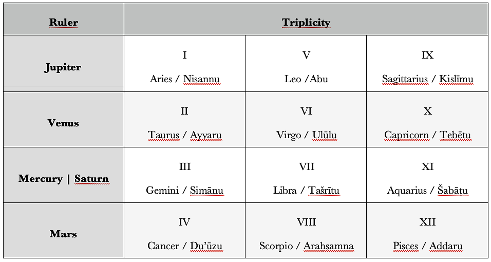
Both terms refer to a common astrological scheme —that of planetary triplicities. We have to imagine a circle divided into twelve equal parts, these being the twelve months or the twelve zodiac signs. Months and zodiac signs correspond, so the first month (nisannu) corresponds to the first zodiac sign (Aries), the second month to the second sign, and so on. In the triplicity scheme, months/zodiac signs are arranged in four groups of three, so that their distance is always four months/signs (i.e., 120°) along the zodiacal circle. Every group of three is ruled by a planet (or two, in the case of Mercury and Saturn for the third triplicity).
This scheme seems to have been creatively interpreted, and, so far, three variations of it have been identified (Pilloni 2024):
In a group of three horoscopes from Babylon, the “house of secrecy/protection (bīt niṣirtu) is related to the triplicity of the month of the solstice or equinox that occurs the closest to the date of birth of the child. For instance, in the Babylonian Horoscope no. 8 (Rochberg 1998) we read: “That year, the 8th of Ṭebētu (Month X) was the date of the (winter) solstice”. The child is born in the “house of secrecy/protection” of Venus” (rev. 1–3). Ṭebētu (month X) is part of the triplicity of months II-VI-X, of which Venus is the ruler. Unfortunately, the significance of the child being born in the “secret house” of a planet is obscure. An important aspect to be pointed out is that this planet is the ruler of a triplicity of a month that is not the month of birth, but that of another astronomical event, namely the solstice or equinox that falls closer to the date of birth.
In the case of a horoscope from Uruk, the “place” (KI) is related to the triplicity of the zodiacal position of the planets at the time of birth. If a planet is in a sign that belongs to the triplicity of that planet, then the child will have good fortune. For instance, in this horoscope (no. 10 in Rochberg 1998), Jupiter is in Sagittarius. Aries-Leo-Sagittarius is the triplicity ruled by Jupiter, that is why the text says “Jupiter in 18° Sagittarius. The ‘place’ of Jupiter: prosperous, at peace; his wealth will be long-lasting, long days” (obv. 6-7).
The third case is a more complicated variation of the triplicity scheme, based on a further subdivision of the months/zodiac signs, called “terms”. The “terms” are subdivisions of each month/zodiac sign into five parts, each assigned to one of the five true planets (excluding the Sun and Moon). What does this have in common with the triplicities? According to the Babylonian scheme of “terms,” (BM 36303+, see Steele 2015), the first “terms“ of each month/zodiac sign corresponds to the planet that rules the triplicity of that month. So, for instance, the first “terms” of Aries/nisannu (=month
I Aries / nisannu
1–5 Jupiter 6–12 Venus 13–20 Mercury 21–25 Saturn 26–30 Mars
I) are dedicated to Jupiter, which is the ruler of the triplicity I-V-IX.
In a group of texts from both Uruk and Babylon, bīt niṣirtu and KI may refer to the day and month of birth. Let us see how it works step by step. The month of birth is divided into five intervals of days, called “terms,” each one assigned to a planet. The day of birth falls into one of these intervals. The bīt niṣirtu and KI are those of the planet assigned to the “terms” (interval of days) of the month of birth. An example might be helpful here. In horoscope no. 13 (Rochberg 1998), the child was born on the fourth day of the fifth month. Later the text says that the child was born in the “house of secrecy/protection” (bīt niṣirtu)of Jupiter. Days 1-5 of the fifth month are dedicated to Jupiter, and it is indeed in Jupiter’s “house of secrecy/protection” that the child was born. Possibly, depending on the planet, different predictions would be made for the child.
Horoscopic practice has changed a great deal since Hellenistic Babylonian times. The idea of calculating the position of the planets along the zodiac on the date of birth and deriving predictions for the child’s life has remained the same, but the way these predictions are derived is completely different. Astrological practices were learned, transformed and enriched in the following centuries by the Egyptians, the Greeks, and the Romans, who introduced other concepts, some of which are still in use today, such as that of the ascendant (zodiac sign rising in the east at the time of birth) and astrological houses. What about the daily horoscopes, certainly the most popular astrological practice nowadays, present on TV, in newspapers or social media? There were methods in Greek astrology to generate forecasts valid down to the day and even hour. An entire discipline of Graeco-Roman astrology, “catarchic,” is devoted to finding the right time (i.e., day and even hour) to plan activities of daily life. Juvenal (Satire 6) writes about Roman women who won’t leave the house without consulting.[1] For the “newspaper horoscopes,” we have to wait until 1937 (AD!), when the British astrologer Richard Harold Naylor starts giving general day-by-day predictions for every person born under a certain (solar) zodiac sign (Holden 2006).
Quoted literature
Holden, J. H. (2006). A History of Horoscopic Astrology: From the Babylonian Period to the Modern Age (2nd ed.). American Federation of Astrologers.
[1] I thank Michael Zellman-Rohrer for providing me with this information on the origin of the day-by-day horoscope.
It is with deep sadness that we announce the death of Kazuya Maekawa, Professor Emeritus at Kyoto University, who passed away unexpectedly on September 12th at the age of 82, following an illness.
Professor Maekawa was widely respected for his extensive research on the socio-economic history of Sumer in the 3rd millennium BCE. He laid the foundation for our understanding of many fundamental issues in the field, and his findings are standing the test of time.
Among his many contributions, Professor Maekawa’s research on Sumerian agriculture revealed the remarkably high barley yield ratios in Southern Mesopotamia during the 3rd millennium BCE. He was a frequent visitor to the British Museum in London, from which he published numerous administrative documents of the Ur III period that were accompanied by his highly precise and beautiful hand-copies. He played a pivotal role in advancing Assyriology in Japan and was a constant source of encouragement and support for younger scholars.
A private funeral service was held for his family.
For a list of several of his publications, please click here.
The new book “Gastrointestinal Disease and Its Treatment in Ancient Mesopotamia” by J. Cale Johnson (Freie Universität Berlin) and Krisztián Simkó (British Museum, London) is now made available as Open Access publication by de Gruyter Publishers in the series initiated by Franz Köcher „Die Babylonisch-Assyrische Medizin in Texten und Untersuchungen“.
This volume contains the first comprehensive edition of the most important medical compendium on gastrointestinal ailments, bile-induced diseases, and fever from ancient Mesopotamia: the Stomach Treatise from Ashurbanipal’s royal library at Nineveh. Assembled three millennia ago from symptom descriptions, drug recipes, incantations, and healing rituals, this treatise formed part of the only authoritative source of knowledge on therapeutic medicine at the time, the Nineveh Medical Encyclopaedia. With numerous textual improvements based on first-hand examinations of the manuscripts and more than a dozen new joins, the Stomach Treatise now finds its rightful place alongside the Ebers Papyrus and the Greco-Roman medical traditions as one of the key representatives of ancient medical thought.
This book is part of the BAM series, Franz Köcher’s magnum opus on Babylonian and Assyrian medicine, which was envisioned to include cuneiform copies, translations, and commentary. Unfortunately, it was unfinished at his death in 2002 with six volumes of cuneiform copies accompanied by brief introductory comments and citation of parallels and duplicates. Publication of the series is being resumed, under the editorship of Robert Biggs and Marten Stol, beginning with Renal and Rectal Disease Texts (BAM 7). The new volumes include full translations and philological commentary, thus making Babylonian and Assyrian medical texts accessible to historians of ancient medicine in up-to-date studies.
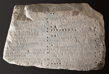
The spread of the Babylonian zodiac[i] is difficult to map with precision. By the time its presence is certain and explicit, the reception is already well-advanced. There are hints suggesting that it had been circulating in some form before catching the attention of the few writers whose works are extant. For instance, evidence from Egypt shows representational and computational influences early on.[ii] The case of the ancient Greek reception is interesting as well. It would seem reasonable to assume that Alexander’s subjugation of the Achaemenid empire fostered – or forced – exchanges between the two cultures. But there is a double problem with this assumption: firstly, exchanges had already taken place before that,[iii] although it is not clear whether it included astrological and/or astronomical knowledge relating to the Babylonian zodiac, nor to which extent. Secondly and conversely, we do not have unambiguous textual evidence of the uniform zodiac in Greek texts before the Phenomena of Aratus of Soles anyways,[iv] i.e. ca. 50 years later.
The Miletus Parapegma, ca. 100 BCE (Antikensammlung, Staatliche Museen zu Berlin, SK 1606 IV Milet Inv. 456B). Note that Greeks did not wait for the Babylonian zodiac to define constellations along the ecliptic or to record the appearance and disappearances of stars during the sidereal year in order to orientate themselves chronologically, i.a. for agricultural reasons, as in Hesiod, Works and Days (vv. 609ff.). On parapegmata and their presence in classical times as well, see Lehoux 2020.
Where could we find echoes of its presence? My exploration project at the CHRONOI center and in close collaboration with ZODIAC aimed at addressing one particular case of a potential reaction to the zodiac, in particular the Babylonian uniform zodiac.
The Letter to Pythocles is a textwritten at the beginning of the 3rd century BCE probably by the famous ancient philosopher Epicurus (ca. 340–270 BCE), or at the very least by his entourage. Despite the title, the text is more of a doctrinal breviary than a proper letter. It deals with many traditional atmospheric, celestial, astronomical and natural phenomena (shooting stars, hail, rainbow, etc) for which Epicurus offers one or more explanations in a heavily summarised form.[v] They all have in common that they do not require the gods’ intervention. A convinced atomist, Epicurus thought it better, i.e. more pleasurable, to support a mechanistic understanding of the world’s events with no meddling from divine power(s). For such interferences could induce the fear that happiness might not be up to us but rather dependent on the discretion of superior entities. This would be fatal to his philosophical therapy based on the somewhat optimistic yet empowering premise that happiness is always at hand.
Given the strong reductionistic drive behind the composition of the Letter and the fact that it was explicitly meant to be a vade-mecum to help the readers remember more easily complex matters, it is striking that we should find a topic seemingly treated twice with a similar if not identical wording. The two passages deal with the so-called episemasiai, i.e., the indications or signs given by certain phenomena that forecast upcoming seasonal or climatic changes. In both, Epicurus is concerned with the behaviour of ‘animals’ and in particular with their causal power:
“Indications [sc. of season/weather] can occur both according to the coincidences of the moments, as for the animals visible around us, as well as by an alteration and modification of the air. For neither of the two possibilities is against the phenomena. But it is impossible to know in what circumstances the cause comes from one or the other.”
“But the indications that occur ‘on the occasion of certain animals’ happen according to the coincidence of the moment. Because the animals cannot force the coming of bad weather and no divine nature orders the exits of these animals and then accomplishes what they indicate. For such nonsense should not come to the mind of any random animal, including those who are rather smart, and even less of that which possesses complete happiness [i.e., the gods].”
In the first passage Epicurus specifies that those animals are among us, par’ hêmin. This suggests that he means actual animals, whose appearances coincide with, say, the arrival of spring. However, in the second one, the animals are not thus qualified. Could it be that Epicurus refers to another kind of animals, namely zodiacal ones?[vi]
There are, at first sight and broadly speaking, several arguments speaking in favour of such an interpretation. First, it would nicely fit the overall topics of the letter, which does not mention animals elsewhere. Second, it would account for, and diminish, the repetitive character of the two passages. Third, we know of an Epicurean rivalry with another school of natural philosophers following Eudoxus of Cnidus’ doctrine in Cyzicus. Since Eudoxus (ca. 390–340BCE) wrote i.a. on sidereal cycles, it could be tempting to read here a criticism of Eudoxus observation of constellations. What is more, the recipient of the letter, Pythocles was in Lampsacus, i.e. geographically close to Cyzicus.
However, the reality is more complex. While still supporting an anti-astrological reading of the passage, my research has led me to distance myself from a strictly zodiacal reading and to discard the Babylonian geometric zodiac as a source altogether. In other words, although there is a clear rejection of astrology as a technique for inferring future events and possibly a rejection of more particular interpretations relating to the behaviour of certain constellations, there is, I think, no reason to limit Epicurus’ argument to zodiacal constellations only, let alone to the 30°-signs of the uniform zodiac. But let us first briefly review the preceding arguments.
The first argument, namely that this text does not mention animals elsewhere, applies only limitedly to a letter dealing with so many different topics. Furthermore, it would not explain the oddity of the first episemasiai, which unambiguously speak of terrestrial animals. Besides, we have testimonies (also in astronomical contexts)[vii] attesting to the observation and interpretation of real animals’ behaviours. The second argument, namely that it explains what would otherwise look like a near repetition, is a bit circular: for such a differentiation to be a solution, we must first assume that repetitions are problematic – which they evidently need not be, given that the text is replete with methodological comments which echo each other in nearly identical forms at the ends of most entries. The third argument is fairly weak too: the evidence that Pythocles was actually interested in Eudoxus’ school is poor at best[viii] and Eudoxus does not seem to have been particularly interested in zodiacal signs for the sake of predictions.[ix]
The first set of arguments is thus not conclusive. And it could be added to this that zodia is the regular word to describe zodiacal signs, whereas zoa is attested only much later with that sense (with Anubion or maybe even Manetho, i.e. in imperial times). But, of course, this too is slightly circular.
Let’s go back to the differences between the episemasiai, building on the par’ hemin. I mentioned before. In the first passage, the behaviours of animals en gros are mentioned parenthetically as one example of coincidental, i.e. non-causal, correlation when it comes to atmospheric or seasonal changes, just like a gush of wind might precede a weather change without being the cause for it. The second passage, on the other hand, aims at something slightly different. The re-affirmation of the fortuitous and meaningless character of animals is more precise (Epicurus speaks of “certain”, tisi,animals and their “outgoings” or “exits”, exodous) and they are not mentioned as a mere example of the misinterpretation of coincidences anymore. The fact that Epicurus focuses on the exit of certain animals suggests that he is thinking of zoa that are not visible all year round. This may seem misleadingly significant to some people, but it is actually “random” (tuchon) accordingly to Epicurus. Making certain zoa causally or at least symbolically significant depends on an arbitrary correlation of fortuitous phaenomena. Furthermore, a new element comes up in addition to the absence of causal power in animals, namely the fact that no “divine nature” (theia phusis) would bother to make animals do their biddings (gods don’t care anyway). This second aspect is completely absent from the first episemasiai. Finally, the ‘animals’ of the second episemasiai almost endorse something of a temporal status with epi (unlike en), which I translated with “on the occasion of”. This is reinforced by the following sugkurema tou kairou, i.e., a “coincidence of the moment”.
All this serves an anti-astrological interpretation well.
Indeed, the meaning of astral conjunction for sugkurema is unproblematic, and exodos in the more technical sense of anatolê (i.e. the rising of an asterism) is plausible. Besides, in both cases, using ambiguous and more generic or non-technical terms could easily serve a derogatory purpose. We can also add that the attitude consisting in hesitating between making stars either living entities endowed with power themselves, such as gods, or mere representations or symbols or tools of the gods – these are in effect the two options offered by Epicurus – fits quite well with the very understanding of stars at that time, hesitating between referential representations or symbols of the gods on the one hand, and sacred entities in their own rights on the other.[x]
Epicurus seeks to deny the causal efficacy of the stars, which include planets, and the significance of their motion even if we cannot explain exactly how it works. But one might argue that by using zoa, literally “living being”, Epicurus runs the risk of animating the asterisms, which would make it hard for him to criticise their traditional ontological status and the predictive semiotic wrongly attached to it. In order to defend an astrological reading of the second episemasiai, one needs to assume that we are facing a counterfactual statement, for stars are not zoa in the first place according to Epicurus. They are neither divine nor animate. But even if they were – so Epicurus – the reasoning would not work. Entertaining an irreligious ambiguity between terrestrial animals and what some people consider to be divine celestial entities could thus prove argumentatively and philosophically coherent – more so than if he had used zodia.[xi]
In sum, if the animals of the first episemasiai must be terrestrial ones appearing around us, the second zoa are more equivocal – possibly deliberately and, I think, productively so. Epicurus does not need either the geometric division of the ecliptic into twelve 30° signs, as elaborated by the Babylonians, or even the zodiacal constellations in them in particular. But an anti-astrological reading makes good, and maybe better, sense in the context of the second episemasiai than considering them a mere reformulation of the first ones. The arrival of the Babylonian zodiac in Greece during or around his lifetime and a growing interest for the “foolish” astrology and the seemingly erratic path of the planets might well have caught his attention.[xii] Given his focus on the removal of divine interference and on building sober hermeneutics when facing distant and unclear phaenomena, Epicurus must have felt the need to react. Stoics approached the matter quite differently – but that’s another story.
References
Bakker, Fredrik A. (2016): Epicurean Meteorology. Sources, Method, Scope and Organization, Brill: Leiden/Boston.
Bollack, Jean / Laks, André (eds.) (1978): Épicure à Pythoclès. Sur la cosmologie et les phénomènes météorologiques, Publications de l’Université de Lille: Villeneuve d’Ascq.
Britton, John P. (2010): “Studies in Babylonian Lunar Theory: Part III. The Introduction of the Uniform Zodiac”, in Archive for History of Exact Sciences 64, pp. 617–663.
Hannah, Robert (2020): “The Moon and the Planets in Classical Greece and Rome”, in: Oxford Research Encyclopedia. Planetary Science, Oxford: OUP, DOI: 10.1093/acrefore/9780190647926.013.196
Hoffmann, Friedhelm (2017): “Astronomische und astrologische Kleinigkeiten VII: Die Inschrift zu Tages- und Nachtlängen aus Tanis”, in R. Jasnow / Gh. Widmer (eds): Illuminating Osiris. Egyptological Studies in Honor of Mark Smith, Atlanta: Lockwood Press, pp. 135–153.
Lasserre, François (1966): Die Fragmente des Eudoxos von Knidos, Berlin: Walter de Gruyter.
Lehoux, Daryn (2020): “Image, Text, and Pattern: Reconstructing Parapegmata”, in A. Jones/C. Carman (eds.): Instruments – Observations – Theories.Studies in the History of Astronomy in Honor of James Evans, DOI: 10.5281/zenodo.3928498.
Oll, Moonika (2015): Greek ‘Cultural Translation’ of Chaldean Learning, diss., University of Birmingham.
Rochberg, Francesca (2010): “Babylonian Astral Science in the Hellenistic World: Reception and Transmission” in Center for Advanced Studies. Ludwig-Maximilian-Universität München. Eseries 4 – https://www.cas.uni-muenchen.de/publikationen/eseries/cas_eseries_nr4.pdf
Sedley, David (1976): ‘Epicurus and the Mathematicians of Cyzicus’, in Cronache Ercolanesi 6, pp. 23–54. Verde, Francesco (ed.) (2022): Epicuro. Epistola a Pitocle, in coll. with Mauro Tulli, Dino De Sanctis, Francesca G. Masi, A
[i] I use here “Babylonian zodiac” to refer to the so-called “uniform zodiac”, i.e. the division of the ecliptic into twelve equal 30° sections named after the constellations they originally contained. This analytical framework was developed during the Achaemenid period and securely attested from the late 5th century BCE – see Britton 2010. For an overview of the Greek reception of Babylonian (or “Chaldean”) astronomy, see Rochberg 2010.
[ii] Cf. Hoffmann 2017; see also Oll 2015, p. 188–199.
[iii] Cf. Aristotle, De caelo 292a (ca. 350 BCE). We know through ancient testimonies that several Greek and Greco-Babylonian authors from the 5th to 3rd century BCE such as Berossus, Callipus, Euctemon, Eudoxus, or Meton were strongly interested in astronomy. But too much has been lost to ascertain their take on the constellations on the ecliptic with certainty. Demetrius I Poliorcetes, king of Macedon from 294 to 288 BCE, is reported to have worn a garment with the twelve signs of the zodiac on it (cf. Athenaeus, Deipn. 535f–536a).
[iv] It seems that Aratus’ knew of the twelves signs as a geometric division of the ecliptic as inherited from Babylon, but he did not really understand it, judging by his own admission (Phaen. 460–461). Note that wars and conquests do not necessarily foster the best environments to share knowledge.
[v] Epicurus relied considerably on earlier sources, e.g., the so-called Syriac meteorology and Theophrastus. See Bakker 2016, 76–161.
[vi] This had been suggested en passant a few times until Bollack and Laks’ commentary (1977, ad loc.), although recent research favours the opposite direction (Verde 2022, 252–3). The topic has not got the attention it deserves to this date.
[vii] E.g., the end of Aratus’ Phaenomena (vv. 733ff.), and the somehow-related On Signs ascribed toTheophrastus.
[ix] Cf. Lasserre 1966. Fragmentary though the remnants are, it is clear that Eudoxus was aware of the ecliptic and of the constellations that are on it. However, this much is nothing exceptional; we actually get it from earlier parapegmata (cf. Lehoux 2020, 109) and it was maybe known to Cleostratus, i.e., as early as in the 6th century BCE, according to Pliny the Elder (NHII 30–31).
[x] The hesitation was probably reinforced by the arrival of Babylonian astronomy. Around the 4th century BCE, the planets started taking on the names of gods and being their attribute while becoming increasingly assimilated linguistically as well (« Hermes’ star » becoming « Hermes » tout court). See Hannah 2020.
[xi] The terms semeia or semata which are regularly used for constellations would generate an unfortunate ambiguity in a context where we are dealing with epi-semasiai. As to the other terms often used, eidos or eidolos, Epicurus had good reasons not to use them; it is a very technical term in his theory of perception (the Lucretian simulacra) referring to the atomic films emanating from objects and hitting our sensory apparatus.
We warmly congratulate Grace J. Park to her new monograph „Focus Construction with kî ʾim in Biblical Hebrew“ which was published by Eisenbrauns, Penn State University Press.
This study uses modern linguistic theory to analyze a frequently recurring syntactic phenomenon in the Hebrew Bible that has thus far resisted explanation: כי אם.
The combination of the two particles כי and אם produces a construction that is notoriously difficult to describe, analyze syntactically, and translate. Dictionaries of Biblical Hebrew offer a dizzying variety of translations for this construction, including “that if,” “except,” “unless,” “but,” “but only,” and “surely,” among other possibilities. In this book, Grace J. Park provides a new approach that strives for greater precision and consistency in translation. Park argues that כי אם is used in three patterns: the “full focus” pattern, the “reduced focus” pattern, and the less common “non-focus” pattern. Her syntactic analysis of all 156 occurrences of the כי אם construction in the Bible lends greater clarity to the contested passages.
Drawing on recent linguistic research into the typology of clausal nominalization as well as previous work on contrastive focus, this innovative project provides important new insight into the syntax of Biblical Hebrew. It will be especially valuable for scholars seeking to translate כי אם more consistently and accurately.
Description according to the website of Eisenbrauns
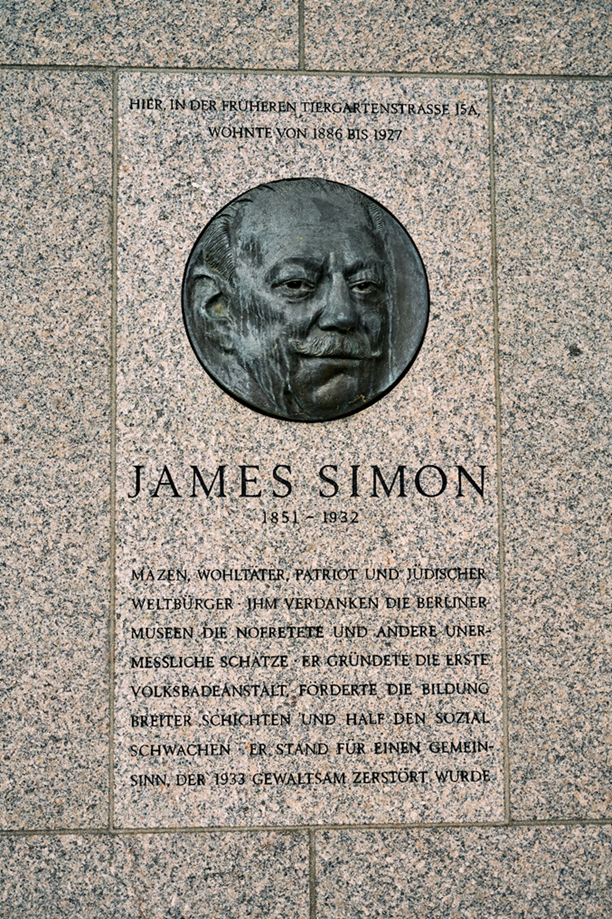
The Deutsche Orient-Gesellschaft (DOG) was founded on January 24, 1898 with the aim of promoting and carrying out archaeological research and archaeological excavations in the regions of ancient Mesopotamia (consequently in today’s West Asian countries). The society thus celebrates its 125th anniversary this year, including a public scientific colloquium and a commemorative publication this summer. Moreover, five years ago (2018) the James-Simon-Galerie was completed as the last and newest building on Berlin’s Museumsinsel and opened a year later (Fig. 1 and 2).
The building functions as the central visitor center of the Museumsinsel and offers space in its basement for exhibitions. It is named after James Simon, an important protagonist of the Berlin art and museum world in Wilhelminian times, who was also particularly important to the DOG. In today’s blog post I would like to give a short biographical sketch of the life of James Simon, his work in founding the DOG and his contributions to ancient West Asian archaeology.
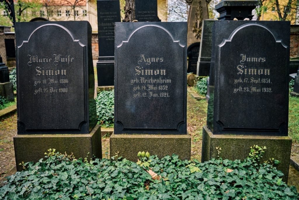
Henri James Simon was born in Berlin on September 17, 1851, into a Jewish family that moved to Berlin from Posen (now Poznań). His father was a textile entrepreneur and cotton merchant who, together with his brother (Henri James’ uncle), founded the cotton company Gebrüder Simon in Berlin. The company benefited from the shortage and increase in the price of cotton in Germany and Europe triggered by the American Civil War (1861–1865) through its extensive stockpiling. Gebrüder Simon became the most important cotton company in Germany at this time. Although James Simon had a keen interest in ancient art and history, he began a merchant apprenticeship in the family business at his father’s instigation.
After his father’s death in 1890, Simon rose to the position of chief executive (alongside his uncle, and later his cousin Eduard). The company continued to prosper, eventually becoming one of the financially strongest and economically most powerful cotton companies in Europe around 1900, and James Simon himself was one of the wealthiest residents of Berlin and Prussia. Alongside his work as a businessman and entrepreneur, James Simon was a founder and supporter of several charities, including educational and social projects (e.g., the Verein für Ferienkolonien, the Verein für Volksunterhaltungen, the Verein zum Schutz der Kinder vor Misshandlung und Ausnutzung, and the Hilfsverein der deutschen Juden). In addition, however, he was also an art collector and an important patron of the Königliche Museen zu Berlin and other museum institutions. Since it was difficult for him, as a Jew in the Wilhelminian Empire, to become involved socially and politically in any other way, he made his impact on social and cultural policy by founding associations and providing financial support. In this way, he distinguished himself as a patriotic and left-liberal citizen of Berlin and Prussia (Fig. 3).
Since the 1890s, Simon focused his cultural-political activities on Western Asia. This happened at a time when the foreign policy of the Wilhelmine Empire was determined by the global political and imperialistic ambitions of Kaiser Wilhelm II. The German Empire was to expand into a political world power and become an imperialist competitor to France and Great Britain. A critical component of this new policy was the development of new colonies. These aspirations were to be fulfilled by the political and economic development of Mesopotamia (then part of the Ottoman Empire). The colonization of Mesopotamia promised access to oil sources and the Persian Gulf. For this purpose, the Ottoman Empire was economically and militarily bound to the German Empire through the dispatch of military advisors and the treaty for the construction of the so-called Bagdadbahn. Alongside these colonialist endeavors in Mesopotamia, cultural-political considerations soon joined in. Wilhelm II and broad circles of German classical scholarship and the interested public agreed that the “Alte Orient” should also be opened up scientifically.
Simon became a member of the so-called Orient-Comité. This committee was established in 1887/1888 with the goal of exploring the “Ancient Orient” by financing archeological excavations and the resale of the found archeological objects to the Königliche Museen at net cost price. However, the museums could not permanently afford to pay the purchase prices for the archaeological objects. As a result, the committee no longer had sufficient funds to continue financing the excavations. Simon criticized the committee’s business model and finally resigned from the Orient-Comité. Subsequently, Simon began preparations to establish a new and more efficient excavation organization that would work closely with the Königliche Museen. Furthermore, in September 1897, Simon financed an expedition planned by the Preußische Akademie der Wissenschaften and the Kommission zur Erforschung der Euphrat- und Tigris-Länder, in which the architect Robert Koldewey (1855–1925) and the orientalist Eduard Sachau (1845–1930) were to identify suitable excavation sites in Mesopotamia. In October 1897, Simon, the egyptologist Adolf Erman (1854–1937) and the archaeologist Alexander Conze (1831–1914) published a circular in which they called for the founding of a new and more efficient excavation society, the DOG. Among others, the two famous and influential ancient historians Theodor Mommsen (1817–1903) and Eduard Meyer (1855–1930) joined this appeal with their signatures. Finally, the foundation of the DOG took place in the Ägyptischen Säulensaal of the Neues Museum on 24th of January, 1898.
Due to his high social standing and his good contacts in business and politics, Simon was able to win many wealthy and influential members and supporters for the DOG. Besides James Simon, who officially only held the position of one of the society’s treasurers, I would like to mention Friedrich von Hollmann (1842–1913) and Bruno Güterbock (1858–1940) as other important early members of the DOG. Friedrich von Hollmann was a former admiral and Prussian secretary of state and acted for the DOG, first as deputy chairman and later as first chairman. He was a friend and confidant of Wilhelm II, whom he often informed about the efforts of the DOG and from whom he successfully solicited financial support for the society. This culminated in 1901 when the emperor became the so-called “Protektor” of the DOG and provided financial support for the society on a regular basis. Already a year earlier, Simon and von Hollmann, through persistent “lobbying”, obtained an annual contribution from the Prussian House of Representatives for the activities of the DOG.
Bruno Güterbock came from a wealthy Jewish banking family, earned a doctorate on Latin loanwords in Irish, and was baptized a protestant in 1879. From 1901 on he acted as secretary of the DOG. In this capacity he functioned as an excavation and scientific organizer. In 1936, Güterbock resigned from his position as secretary of the DOG as a direct result of the Nazi takeover and the introduction of the Nürnberger Gesetze of 1935 with which the Nazis sought to provide a legal foundation for their racist and anti-Semitic ideology. In addition to Güterbock’s resignation, the DOG also suffered the loss or resignation of its numerous other members of Jewish origin and religion during this period.
It is also noteworthy, that Güterbock functioned as editor of the Mitteilungen der Deutschen Orient-Gesellschaft and the Wissenschaftlichen Veröffentlichungen der Deutschen Orient-Gesellschaft. In addition, Güterbock also organized the famous and sometimes sensational annual lecture evenings of the DOG. These were held at the Berliner Singakademie from 1901 on and were attended by Wilhelm II from 1902 to 1914, making these events some of the most important societal occasions in imperial Berlin. Simon conceived these lectures to present the latest excavation results of DOG-funded research projects to a broad public, and in turn, to attract more members and funds to the DOG.
After the completion of the above-mentioned Mesopotamia expedition by Koldewey and Sachau in May 1898, the board of the newly founded DOG met to discuss the results of the expedition. It was agreed that Babylon would be the site of the first German excavation in Mesopotamia. The excavations in Babylon under the direction of Robert Koldewey were financed and organized by the DOG and began work already in March 1899. The excavations in Babylon lasted until 1917 and were the first to use historical and stratigraphic methods, which was to have a major impact on 20th-century archeology.
According to these scientific methods, the focus of the archaeological excavation was no longer the search for ancient works of art or other supposed archaeological “treasures”, but rather the architectural history and topographical development of ancient cities. Other vital DOG projects before World War I were the excavation in Assur from 1903 to 1914, as well as archaeological field research projects in Palestine and Egypt, which were mainly financed privately by James Simon.
World War I ended with the defeat of the German Empire and the abdication of Wilhelm II. The Weimarer Republik was the first German parliamentary democracy and became the state successor to the German Empire, ending its colonial and imperialist ambitions. At this time, James Simon was involved with the liberal Deutsche Demokratische Partei, his company, however, did not expand further since it ran into economic difficulties due to poor decisions by the company management and rising inflation. At the time of the Weimarer Republik, the DOG was also economically weak as well as scientifically, culturally, and politically isolated, so further field research was not possible. At that time, the scientific focus of the society was the publication of the wide variety of scientific discoveries that had been made in the previous decades as part of the archaeological fieldwork. James Simon died on May 23, 1932 and was buried in the Jewish Cemetery on Schönhauser Allee in Berlin (Fig. 4).
He died before the Nazis established their terror regime, initiated the persecution and extermination of the Jews and triggered World War II. The Nazis made Simon’s services to the collections of the Museumsinsel unrecognizable by removing Simon’s foundations as well as plaques and tributes to James Simon in the exhibition rooms of the museums, thus leaving him forgotten.
The commemoration of Simon has grown in recent decades with the publication of Olaf Matthes’ work on the patronage of James Simon and other publications dealing with Jewish patronage in the Wilhelmine Empire. By naming the visitor center of the Museumsinsel after James Simon, the Staatliche Museen zu Berlin (as successorof the Königliche Museen zu Berlin) has created an enduring memorial to one of their most influential and important benefactors and donors.
Bibliography
S. Böhme, Die Goldene Leibniz-Medaille, eine Grußblatt-Sammlung, eine „Festschrift“ sowie ein Exlibris und die „deutsche Wissenschaftstradition“. Späte Ehrungen für Bruno Güterbocks (1858-1940) „unendliche Arbeit“ als Schriftführer der DOG im Jahr 1928, in: J. Marzahn – F. Pedde (Hrsg.), Hauptsache Museum. Der Alte Orient im Fokus. Festschrift für Ralf-B. Wartke (Münster 2018), 311–329
E. Cancik-Kirschbaum, Henri James Simon zur 150. Wiederkehr seines Geburtstages, MDOG 133, 2001, 5–6
N. Crüsemann, Ein Vorläufer der DOG. Das Orient-Comité, in: G. Wilhelm (Hrsg.), Zwischen Tigris und Nil. 100 Jahre Ausgrabungen der Deutschen Orient-Gesellschaft in Vorderasien und Ägypten (Mainz 1998), 13
T. W. Gaehtgens, Die Berliner Museumsinsel im Deutschen Kaiserreich. Zur Kulturpolitik der Museen in der wilhelminischen Epoche (München 1992)
C.-M. Girardet, Jüdische Mäzene für die Preußischen Museen zu Berlin. Eine Studie zum Mäzenatentum im Deutschen Kaiserreich und in der Weimarer Republik Egelsbach 1997)
S. Hofmeister, Unter den neuen Kolonnaden. James-Simon-Galerie, in: F. Heilmeyer – S. Hofmeister (Hrsg.), Berlin. Urbane Architektur und Alltag seit 2009 (München 2022), 63–72
F. Kaltenbach, James-Simon-Galerie, Berlin, DE, in: S. Hofmeister (Hrsg.), David Chipperfield Architects3. Architektur und Baudetails (München 2022), 54–63
O. Matthes, Eduard Meyer und die Deutsche Orient-Gesellschaft, MDOG 128, 1996, 172–218
O. Matthes, Der Aufruf zur Gründung der Deutschen Orient-Gesellschaft vom November 1897, MDOG 130, 1998, 9–16
O. Matthes – J. Althoff, Die ‘Königliche Kommission zur Erforschung der Euphrat- und Tigrisländer‘, MDOG 130, 1998, 241–254
O. Matthes, Bruno Güterbock und Ulrich von Wilamowitz-Moellendorff, in: B. Böck – E. Cancik-Kirschbaum – T. Richter (Hrsg.), Munuscula Mesopotamica. Festschrift für Johannes Renger (Münster 1999), 277–284
O. Matthes, Friedrich von Hollmanns Bedeutung für die Deutsche Orient-Gesellschaft, MDOG 131, 1999, 191–208
O. Matthes, James Simon. Mäzen im Wilhelminischen Zeitalter (Berlin 2000)
E. Meyer, Fünfundzwanzig Jahre Deutsche Orient-Gesellschaft, MDOG 62, 1923, 1–25
E. von Schuler, Siebzig Jahre Deutsche Orient-Gesellschaft, MDOG 100, 1968, 6–22
A. Schwarz, Weiterbauen auf der Museumsinsel. Zum Entwurf der James-Simon-Galerie, in: E. M. Froschauer – W. Lorenz – L. Rellensmann – A. Wiesener (Hrsg.), Vom Wert des Weiterbauens. Konstruktive Lösungen und kulturgeschichtliche Zusammenhänge (Basel 2020), 249–254