Landsat 8 is the latest installment of the U.S. Landsat satellite series, operated by National Aeronautics and Space Administration (NASA) and United States Geological Survey (USGS). The Landsat program represents the world’s longest continuously acquired collection of spaceborne data in history and since late 2008, all data were made available to all users free of charge.
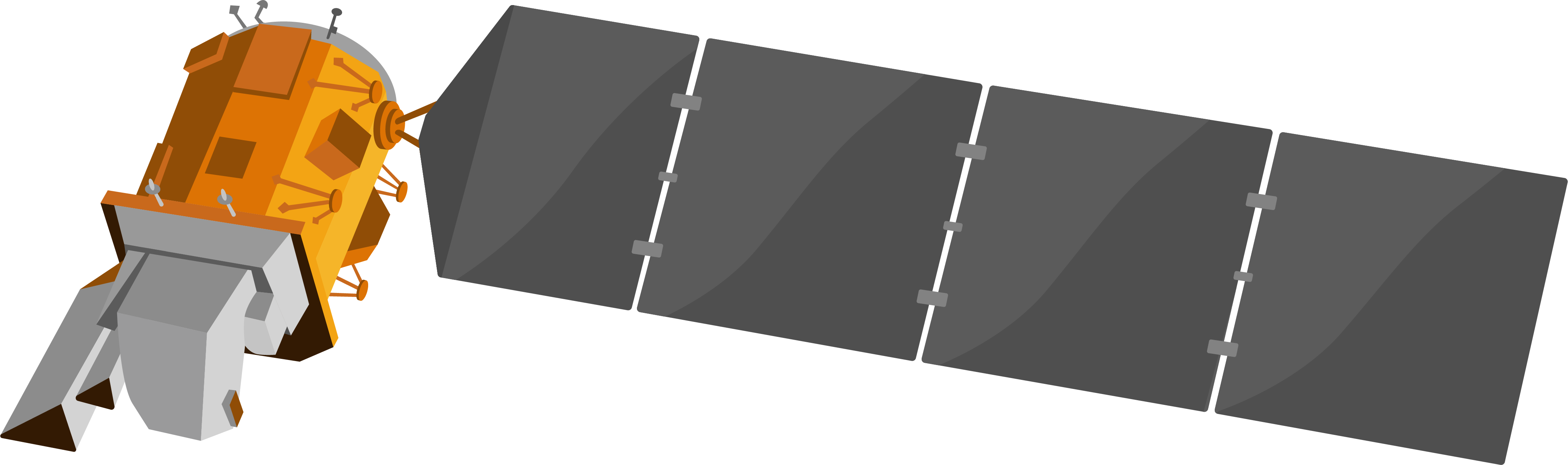
The Landsat 8 satellite was launched on February 11, 2013 by an Atlas-V rocket in California, as part of the long-term Earth Observation Systems (EOS) program. Like its predecessors, Landsat 8 is a passive satellite with a multispectral, optical sensor.
For the first time in the Landsat program, the payload consists of two push-broom instruments onboard – the Operational Land Imager (OLI) and the Thermal Infrared Sensor (TIRS). OLI uses a four-mirror telescope and collects data for visible, near infrared, and short wave infrared spectral bands as well as a panchromatic band. TIRS collects two spectral bands in the thermalinfrared (TIR).
Together, they scan the electromagnetic spectrum in 11 separate bands in a moderate geometric resolutions of 15-30 m:
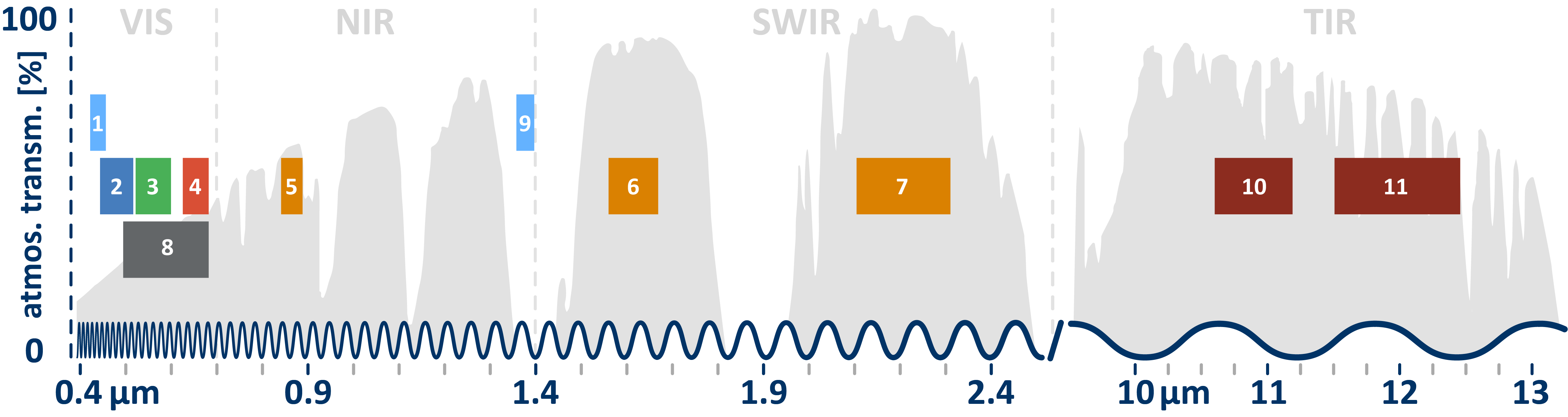
Each of these channels has been designed to perform certain tasks, e.g., retrieving atmospheric aerosol properties and detect cirrus clouds for corrections of atmospheric distortions (bands 1 & 9), or measuring thermal energy emitted by objects for mapping land surface temperatures (bands 10 & 11):
| BAND | SPECTRAL | WAVELEN. [µm] | GEOM. [m] | SENSOR | |
| 1 | aerosols | 0.435 – 0.451 | 30 | OLI | |
| 2 | blue | 0.452 – 0.512 | 30 | OLI | |
| 3 | green | 0.533 – 0.590 | 30 | OLI | |
| 4 | red | 0.636 – 0.673 | 30 | OLI | |
| 5 | NIR | 0.851 – 0.879 | 30 | OLI | |
| 6 | SWIR-1 | 1.566 – 1.651 | 30 | OLI | |
| 7 | SWIR-2 | 2.107 – 2.294 | 30 | OLI | |
| 8 | pan | 0.503 – 0.676 | 15 | OLI | |
| 9 | cirrus | 1.363 – 1.384 | 30 | OLI | |
| 10 | TIR-1 | 10.600 – 11.190 | 100 | TIRS | |
| 11 | TIR-2 | 11.500 – 12.510 | 100 | TIRS |
In the following a profile with the most important characteristics of the sensor is given. For much more detailed information, please refer to the Landsat 8 User Guide!
| geometric |
|
| spectral |
|
| radiometric |
|
| temporal |
|
Data Products
Landsat 8 acquires over 500 scenes each day. Most acquired scenes are downlinked to the Landsat Ground Network and made available for download within 24 hours after acquisition. Those scenes are usually uploaded to and stored in the USGS global archive. All Landsat standard data products are processed using the Landsat Product Generation System (LPGS) and come as compressed “.tgz”-files, which can be uncommpressed by using file archiver, such as 7-Zip or WinRAR. Once uncompressed, the image data is in GeoTIFF output format and projected to the Universal Transverse Mercator (UTM) map projection with the World Geodetic System 84 (WGS84) datum.
There are two main data products, which differ in the previous level of preprocessing: one without an atmospheric correction (Level-1) and one with (Level-2). Information on the processing level designations can be found in the metadata file (“.MTL.txt”) that is delivered with the Landsat 8 product.
Level-1 products
Standard Landsat 8 data products consist of quantized and calibrated scaled Digital Numbers (DN) representing the multispectral image acquired by OLI and TIRS. They can be converted to Top Of Atmosphere (TOA) reflectance and radiance values by using radiometric rescaling coefficients as described in this USGS guide.
Level-1 Landsat scenes with the highest available data quality are declared as Tier 1 (L1TP) and are considered suitable for time-series analysis. Tier 1 includes data that have well-characterized radiometry and consistent georegistration and that is inter-calibrated across the different Landsat instruments.
- L1TP (Tier 1): This product offers radiometrically calibrated and orthorectified pixels by using auxiliary digital elevation models (DEM) and ground control points (GCP) to correct for relief displacement
- L1GT (Tier 2): worse, since GCP were not available
- L1GS (Tier 2): worst, since neither GCPs nor DEMs were available
Level-1 products contain the following 14 files once uncompressed:
- Level-1 bands (1, 2, 3, 4, 5, 6, 7, 8, 9, 10 , and 11)
- Quality Assessment (QA) Band
- Angle Band Coefficients file
- Metadata text file (MTL.txt)
Level-2 products
USGS offers on-demand Surface Reflectance data products (Level-2). Surface Reflectance products provide an estimate of the surface spectral reflectance as it would be measured at ground level in the absence of atmospheric scattering or absorption. Surface reflectance values are scaled between 0 % and 100 %. This atmospheric correction is done via the Landsat Surface Reflectance Code (LaSRC), which utilizes the Landsat band 1, auxiliary MODIS data and radiative transfer models.
Keep in mind: This product contain neither Level-1 TOA layers nor thermal bands!
Although these data are also free, it may take several days for the processing to be completed by the servers of the Earth Resources Observation and Science (EROS) Center, before you are able to download them (read on: USGS Earth Explorer).
Level-2 products contain the following 13 files once uncompressed:
-
- Level-2 bands (1, 2, 3, 4, 5, 6, and 7)
- Radiometric Saturation QA band (radsat_qa.tif
- Surface Reflectance Aerosol QA band (sr_aerosol.tif)
- Level-2 Pixel Quality Assessment band (pixel_qa.tif)
- Surface Reflectance metadata file (.xml)
- Level-1 metadata file (MTL.txt)
- Level-1 Angle Coefficient file (ANG.txt)
In general, we recommend you to use the Level 2 products, especially if you work multitemporally, since the radiometry of surface reflectances is more comparable between scenes.
The official product guide offers more information on the Level-1 and Level-2 Landsat products.